1. INTRODUCTION
The vector map, is also called GIS vector map, is a vector–based collection of Geographic Infor- mation System (GIS) data about earth at various levels of detail. Vector map is created and devel- oped by the merging system of cartography, stat- istical analysis, and database technology based on vector model [1,2]. Vector data provide a way to represent real world features within the GIS envi- ronment because vector data has advantages as
need a small space or place for storage data; has a high spatial resolution and graphic representation spatial data closely likes handed map; easily for making projection and coordinates transformation [3,4]. For those advantages, vector map is used in many domains, and GIS applications use vector map have provided general users with easy access to services via mobile devices or internet access.
But the producing process of a vector map is con- siderably complex and the maintenance of a digital map requires substantial monetary and human
Selective Encryption Scheme for Vector Map Data using Chaotic Map
N.V. Bang
†, Kwang-Seok Moon
††, Sanghun Lim
†††, Suk-Hwan Lee
††††, Ki-Ryong Kwon
†††††ABSTRACT
With the rapid interest in Geographic Information System (GIS) contents, a large volume of valuable GIS dataset has been distributed illegally by pirates, hackers, or unauthorized users. Therefore the problem focus on how to protect the copyright of GIS vector map data for storage and transmission. But GIS vector map data is very large and current data encryption techniques often encrypt all components of data. That means we have encrypted large amount of data lead to the long encrypting time and high complexity computation. This paper presents the selective encryption scheme using hybrid transform for GIS vector map data protection to store, transmit or distribute to authorized users. In proposed scheme, polylines and polygons in vector map are targets of selective encryption. We select the significant objects in polyline/polygon layer, and then they are encrypted by the key sets generated by using Chaotic map before changing them in DWT, DFT domain. Experimental results verified the proposed algorithm effectively and error in decryption is approximately zero.
Key words: GIS Vector Map, Selective Encryption, DWT, DFT, Chaotic Map.
※ Corresponding Author : Ki-Ryong Kwon, Address:
(608-737) (599-1) Daeyeon-3dong, Namgu, Busan, Korea, TEL : +82-51-629-6257, FAX : +82-51-629-6230 , E-mail : [email protected]
Receipt date : Apr 10, 2015, Revision date : May 16, 2015 Approval date : Jun 1, 2015
†††Dept. of IT Convergence and Applications Eng., Pukyong National University
(E-mail : [email protected])
†††Dept. of Electronics Eng., Pukyong National University (E-mail : [email protected])
†††Korea Institute of Civil Engineering and Building Technology (E-mail : [email protected])
†††††Dept. of Information Security, Tongmyong University (E-mail : [email protected])
†††††Dept. of IT Convergence and Applications Eng., Pukyong National University
※ This research was supported by Basic Science Research Program through the National Research Foun- dation of Korea(NRF) funded by the Ministry of Educa- tion(NRF-2014R1A1A4A01006663), IT/SW Creative re- search program supervised by the NIPA (NIPA-2014- 1195), and a grant from a Strategic Research Project (Development of a road weather information retrieval system based on automotive sensors) funded by the Korea Institute of Civil Engineering and Building Technology.
resources. And any companies can buy it, make il- legal copies from them and distribute or sell them easily many times without taking any permission from the original GIS data provider. Moreover, ap- plications of vector map in military domain require the high security, and must be kept away from un- authorized users. So vector map is necessary to be protected and prevent illegal duplication and dis- tribution of it.
Our paper is organized as follows. In section 2, we discuss the related works and in section 3, we explain the proposed selective encryption algorithm in detail. Then, in section 4 we perform experi- ments and discuss about the experimental results, evaluate the performance of algorithm. Finally, we conclude this paper in section 5.
2. RELATED WORKS
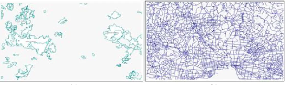
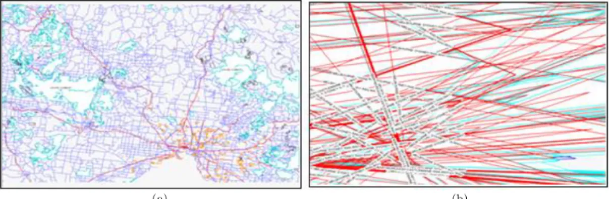
The GIS vector map data includes layers. Each layer is a basic unit of geographical objects which are described and managed in a map. These objects describe the topography and geographical features of real objects or a certain place. Each layer con- sists of an amount of vector data which uses pairs of coordinates to describe as point, polyline and polygon [5,6], as shown Fig. 1.
Officially, the point is used to present simple or small objects in the reality on the map while poly- line and polygon are used to present complex and large objects. Polyline is used to represent objects as road, contour line, and railway, so on. Polygon
is used to represent objects as building, area, lake, boundaries and so on. The general approach of se- lective encryption is to separate the content into two parts. The first part is the public part, which is un-encrypted and accessible by all users [7-11].
The second part is the protected part; it is encrypted.
From these reasons, our algorithm only per- forms selective encryption for polylines and poly- gons in GIS vector map. Only authorized users have access to protected part. Polylines and poly- gons are selected, and encrypted by the key sets generate from Chaotic map before changing them in DWT, DFT domain based on their geographical features [12,13]. Our algorithm encrypts only some coefficients in DWT domain by changing DC value in DFT domain but it changes the whole map.
3. PROPOSED ALGORITHM
Our method aim to encrypt GIS vector map per- ceptually and entirely using a few of selected val- ues, it is called as vector map selective encryption.
3.1 Encryption process
The schematic diagram of the proposed techni- que is illustrated in Fig. 2, and the step-by-step procedure is explained hereafter.
∙ An original GIS vector map is
∈
with
layers in a map. A layer
is a set of
(a) (b)
Fig. 1. An example GIS vector map; (a) Forest layer, (b) Road layer.
objects of polylines and polygons
∈
with
is the total number of objects in
.
∙ An object
have properties the total number of points (vertices) and the area of bounding box. Calculate the area threshold (
) and the point threshold (
) for each layer.
∙ Identify the significant objects by comparing the total number of points and the area of bounding box with two thresholds. For an insignificant object, leave it unencrypted. For a significant object, using encryption block to encrypt it by key sets generated from Chaotic map and user’s password before changing them in DWT, DFT domain.
3.1.1 Object classification
Our algorithm only performs selective en- cryption for polyline/polygon in GIS vector map.
However, each polyline/polygon layer has many objects and if we encrypt all of them, we also need many computation time. Each object has attributes such as the number of points (P), the area of bounding box (A), as shown in Fig. 3(a). Many ob- jects are created from a few points and the value of bounding box’s area is very small when compare with other objects in a layer. This object is very simple and mark it as an insignificant object, as shown in Fig. 3(b). With objects include many points and the area of bounding box is larger than, it also complex than and mark it as a significant object, as shown in Fig. 3(c).
Thus, we used probability distribution to define thresholds in each layer and identify which object is a significant or insignificant object by comparing object’s features with thresholds.
The area threshold (
) and the point threshold (
) in a layer are defined as following:
∙ A layer
:
∈
,
is the total num- ber of objects in
.
∙ A object
include two features: The area of bounding box (
) and the total number of points (
).
∙ Therefore, we have:
∈
and,
∈
in layer
.
∙ We used probability distribution to find thresh- old in set
,
:
∈
and
(1)
∈
and
(2)
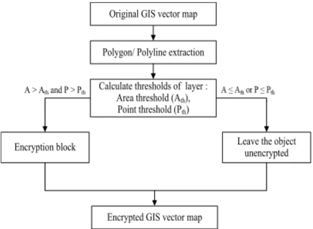
Original GIS vector map
Polygon/ Polyline extraction
Calculate thresholds of layer : Area threshold (Ath), Point threshold (Pth)
Leave the object unencrypted Encryption block
A > Ath and P > Pth
Encrypted GIS vector map
Fig. 2. Schematic diagram for proposed encryption technique.
(a) (b) (c)
Fig. 3. An example about objects in a layer.
3.1.2 Chaotic map
The classical chaos system is a logistic map, which can be defined by following:
(3)
Here ≤ ≤ is the coefficient of the map, k=0, 1, 2, . . . and all the values of {
} appear in the range [0,1] for the initial value
∈ . It is noted that Eq. (3) has the chaotic behavior [14,15] when
appears in the range ,and especially the chaotic behavior called Pomeau–Manneville sce- nario [16] when appears in the range . 3.1.3 Encryption block
We used the key to create two key sets (length of key set is 8) for a layer. It is created randomly the first key in each key set by SHA-512 algorithm from user key with key length is 512 bit. Other keys are generated by using Chaotic map as Eq. (3).
Therefore, we have two key sets:
∈ ,
∈ and DC encryption value:
.
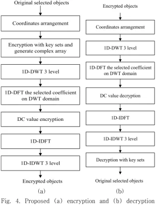
For a significant object, using encryption block to encrypt it, as shown in Fig. 4(a) and illustrate in Fig. 5, the step-by-step procedure is explained hereafter.
∙ We arrange all X, Y coordinates of the sig- nificant objects in a layer, into two 1D-arrays, given the length of segment is 8, the total num- ber of segments in each array is: , N is the length of 1D-array.
∙ With each segment, we encrypt all coordinates by using keys of two key sets a, b and create complex numbers as equation:
∈
∙ Apply DWT-3 level for each segment to get a set of first transformed values. In each segment, select the first coefficient of first transformed values and continue to apply DFT to get a set of second transformed values.
∙ After DFT processing, we continue to encrypt
by multiplying the first DC coefficient with DFT encryption value by equation (4).
(4)
∙ We perform IDFT to get a set of encrypted val- ues of second transformed values. Replace the first coefficient in each segment by one en- crypted value in step 6 and IDWT-3 level with each segment to get a set of encrypted values of first transformed values.
∙ Assign X, Y encrypted coordinates of the sig- nificant objects by image, real part of the en- crypted complex values that is generated in step 7.
3.2 Decryption process
The reverse process is applied to decrypt the en- crypted map. To perform decryption, after we cal- culate thresholds in a layer, we use the decryption block to decrypt the encrypted significant objects,
Encryption with key sets and generate complex array
1D-DWT 3 level
1D-DFT the selected coefficient on DWT domain
DC value encryption
1D-IDFT
1D-IDWT 3 level
Encrypted objects Original selected objects
Coordinates arrangement
Decryption with key sets 1D-DWT 3 level
1D-DFT the selected coefficient on DWT domain
DC value decryption
1D-IDFT
1D-IDWT 3 level Encrypted objects
Original selected objects Coordinates arrangement
(a) (b)
Fig. 4. Proposed (a) encryption and (b) decryption
process for vector map.
as shown in Fig. 4(b). If correct key is employed at the time of decryption, then the decrypted map would by a replica of the original map. In the case of an incorrect decryption key, the output map is vary.
4. EXPERIMENTAL RESULTS
4.1 Visualization
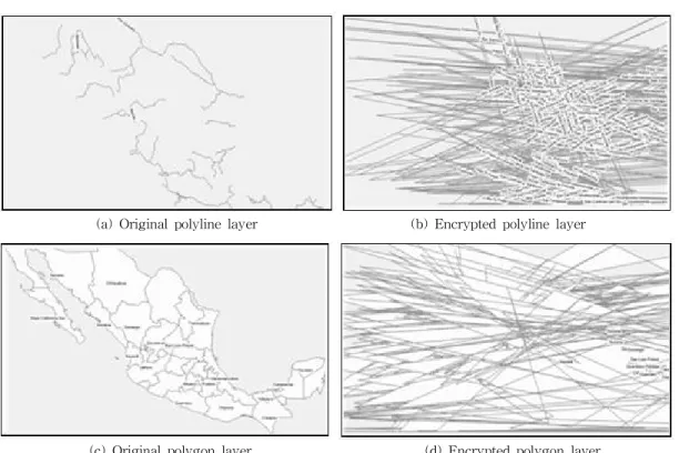
Experimental results figure 6 and figure 7 show
the proposed algorithm changes whole maps. The proposed method has much lower computational complexity than AES (Advanced Encryption Standard ) or DES (Data Encryption Standard) be- cause we only select some coefficients in DWT do- main and one DC value in DFT domain, encrypt it by key values.
4.2 Distance measure
The distance between original map and en-
Zi1
Zi2
Zin
…
Zi11 Zi12 … Zi17 Zi18
… Segment
Zi21 Zi22 … Zi27 Zi28
Zin1 Zin2 … Zin7 Zin8
DWT-3 level
DWT-3 level
DWT-3 level Wi1
Wi2
Win
…
Wi11 Wi12 … Wi17 Wi18
…
Wi21 Wi22 … Wi27 Wi28
Win1 Win2 … Win7 Win8
DFT, encrypt first coefficient and IDFT
Ei1
Ei2
Ein
…
Ei11 Ei12 … Ei17 Ei18
…
Ei21 Ei22 … Ei27 Ei28
Ein1 Ein2 … Ein7 Ein8
IDWT-3 level
IDWT-3 level
IDWT-3 level Zijk = Xijk *ak +j*Yijk *bk, k? [1, 8]
Fig. 5. Selective encryption process.
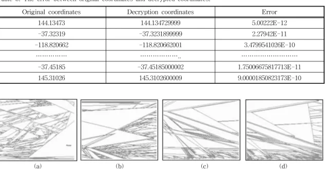
(a) Original polyline layer (b) Encrypted polyline layer
(c) Original polygon layer (d) Encrypted polygon layer.
Fig. 6. Experimental results of polyline/polygon layer.
crypted map is computed by equation (5):
′
(5)
With L is a original map,
′ is corresponding encrypted map, N is the total number of objects in original map. And
is distance between corresponding objects in
′ and L.
We used same original map to experiment with different passwords K1 # K2. Then we calculate
′ distance of each experimental time, as show in Table 1. .
4.4 Decryption error
Our selective encryption scheme only changes values of vertices in polylines and polygons of map.
It did not alter the size of encrypted file, as shown in Table 2. In addition, we use hybrid transform to encrypt coordinates, that means, if we have an input sequence
, and we perform DFT to get
, and next we perform IDFT to get input sequence again
′
, it shows that
′