City Radio Map Construction for Wi-Fi-Based
Citywide Indoor Positioning
DONGSOO HAN, (Member, IEEE), AYESHA SAHAR , JOSEPH BERKNER, AND GUNWOO LEE School of Computing, Korea Advanced Institute of Science and Technology, Daejeon, South Korea
Corresponding author: Dongsoo Han (dshan@kaist.ac.kr)
This work was supported in part by the U.S. Department of Commerce under Grant BS123456.
ABSTRACT A Wi-Fi fingerprint consists of received signal strength values at a particular location along with the location information. A Wi-Fi radio map is constructed by maintaining a database of Wi-Fi fingerprints at various points in a building. A city radio map is a collection of radio maps for most buildings in a city. A highly precise citywide indoor positioning service is possible, if an accurate city radio map is available. However, tremendous time and effort are required to construct a city radio map through manual calibration. This paper proposes a method for constructing a city radio map through the crowdsourcing of Wi-Fi fingerprints from numerous smartphones. The proposed method classifies the buildings in a city into three categories: buildings in residential areas, commercial areas, and public areas. Then, it develops location-labeling techniques appropriate for the collected fingerprints from buildings in each category. Experiments conducted in the cities of Daejeon and Seoul revealed that the proposed method can construct a precise city radio map with minimal cost in a short period of time. Once city radio maps are constructed for most cities around the world, the global indoor positioning system will be completed.
INDEX TERMS City radio map, crowdsourcing, indoor positioning, semi-supervised machine learning, simultaneous calibration and address mapping (SCAM).
I. INTRODUCTION
The incorporation of indoor positioning services into mobile devices makes daily life safer and more convenient. Naviga-tion and route guidance can be utilized in spaces where this service was not previously available. Outdoor car navigation services are expanding their service areas to indoor environ-ments to provide indoor-and-outdoor integrated navigation services [1]–[3]. This is especially helpful for emergency ser-vices to conduct rescue tasks more effectively by immediately locating a person who is in danger regardless of geographic location. In addition, various unprecedented indoor location-based services will emerge from the utilization of the citywide indoor positioning service.
There have been many attempts to provide a precise indoor positioning service using various signals and sensors [4]–[7]. However, a building-based perspective is not a feasible approach because overall coverage is required to provide a valuable and complete system to users. Nevertheless, there have been only a few attempts to provide a precise indoor positioning service covering a large number of buildings in
The associate editor coordinating the review of this manuscript and approving it for publication was Bohui Wang.
a city [8]. One fundamental question is what kind of sig-nal input should be used for this kind of system? In fact, many signal sources, such as cell towers, GPS, and Wi-Fi, can be used for citywide indoor positioning. In this study, we consider Wi-Fi signals as the best candidate because Wi-Fi infrastructures have already been deployed in most buildings in cities and they can achieve relatively precise positioning accuracy [9]. This is a beneficial starting point for the devel-opment of a citywide indoor positioning service.
The construction of a radio map is another crucial initial step towards implementing an indoor positioning service. A radio map models the location characteristics of each point in an indoor environment from a collection of fingerprints of received signal strengths (RSSs) from multiple Wi-Fi access points (APs), which serve as reference locations [10]. How-ever, these APs are limited to only one or a few specific buildings. By contrast, a citywide radio map aims to model Wi-Fi signal patterns at specific points within most buildings in a city. Radio maps are usually constructed by manual calibration or machine learning techniques for the location-labeling of crowdsourced fingerprints. Crowdsourced finger-print techniques have been considered as a practical approach to constructing a city radio map because the alternative
of manual calibration requires tremendous time and human resources. When using crowdsourced data, location-labeling techniques typically have two steps. In the first step, refer-ence locations are acquired, and in the second step, location-labeling of the crowdsourced fingerprints is conducted using these references, which provides location information of the fingerprints [11].
A city is composed of buildings with various heights that are used for various purposes, such as residence, business, shopping, exhibition, and entertainment. Consequently, radio maps for buildings cannot be appropriately constructed with only one particular location-labeling method. For example, apartment hallways can be considered solely as transit spaces that connect the entrance of the building with the entrances of each apartment. By contrast, shopping mall hallways are occupied by people who are resting, window shopping, meet-ing, etc., which means they have a much higher impor-tance regarding navigation and localization. Therefore, this paper proposes a practical framework for citywide radio map construction by considering different types of buildings and assigning distinct crowdsource-based methods to each build-ing category, which means that traditional manual calibration is not required. Experiments performed for each building type showed promising accuracy results, thus demonstrating the suitability of the proposed framework.
II. RELATED WORK
Many crowdsourced-based location-labeling methods have been invented in the last several years. The first approach relied on user contributions for the collection of fingerprints and addresses [12]. This method employs the app RedPin, which allows users to enter location information, such as the names and addresses of shops and restaurants and evaluate or leave comments on them using the app during their stay. This approach is called explicit crowdsourcing because it cannot collect fingerprints and place information without explicit user contributions.
Other techniques that are not reliant on the direct input of users exist to derive address-based reference locations. For instance, Internet of Things (IoT) devices and home appli-ances, such as Internet protocol televisions (IPTV), set-top boxes, internet-connected refrigerators, and smart machines, can also be used for the collection of address-based refer-ence locations. They collect fingerprints from which their deployed address information should be available. It is known that the deployed addresses of home appliances are left to distributors or manufacturers for the delivery of goods or after-sale services. By using this address information, the col-lection time of references in the location-labeling of finger-prints is very low because the references are collected directly from smart devices without explicit contributions from users. Owing to this lack of direct user participation, this method is called implicit crowdsourcing and is considered effective in constructing radio maps of areas inside buildings [13], [14].
In the above mentioned methods, the reference locations are collected under the assumption that the addresses are available. Thus, the main issue in collecting reference loca-tions is how to map collected fingerprints to the available addresses. Besides the possibility of querying third party databases, in some situations, addresses and fingerprints can be collected simultaneously through smartphone apps, such as online shopping apps. Online shopping app users must enter their home or office addresses for the delivery of their items. In this situation, the mapping of address and fingerprint is much simpler than in the previous methods because the fingerprints can be labeled with the simultaneously entered addresses. However, mislabeled fingerprints should later be filtered out through post processing.
The true essence of crowdsourcing is the collection of datasets with unconscious user participation. Many researchers have proposed implicit crowdsourcing systems for indoor maps, which are especially useful for large areas. Yang et al. proposed the method of locating in fingerprint
space(LiFS), which does not require any active
participa-tion from the users [15]. LiFS uses multidimensional scal-ing (MDS) technology to record the fscal-ingerprints of users, meanwhile mapping the Wi-Fi fingerprints to reference loca-tions using the movement paths. Essentially, LiFS sets up a geographical relationship between fingerprints using the distance between two endpoints. It also does not require AP information as this cannot be obtained in office or commercial buildings. Similarly, Rai et al. scanned the Wi-Fi fingerprints of users as they entered an indoor environment [16]. The author used data from inertial sensors of smartphones to track users and maintained a fingerprint database without user interaction. The author named this system Zee, which is capable of running in the background and requires no user interaction to collect fingerprints. Unsupervised learning has also been used for crowdsourced Wi-Fi fingerprint data by some researchers in [17]. The authors collected Wi-Fi fin-gerprints without reference locations following unsupervised learning to cluster the fingerprints. This method proves that it is possible to construct a precise radio map without collecting reference locations. Furthermore, Graph-SLam develops a system that can be installed on user devices to enable users to share their walking path and Wi-Fi signals without any explicit efforts [18].
Based on the above mentioned methods, the effective-ness of the crowdsourcing can be inferred in the field of indoor positioning system. However, all the existing sys-tems focus on covering a specific type of building. The buildings in a city have different types of architectures and purpose. A method that performs well in a specific type of architecture may not be effective for other types of build-ings. The proposed method covers this limitation by clas-sifying the buildings of a city in three types and proposes a separate method for each type. Eventually, a citywide indoor positioning system is achieved which is not available before.
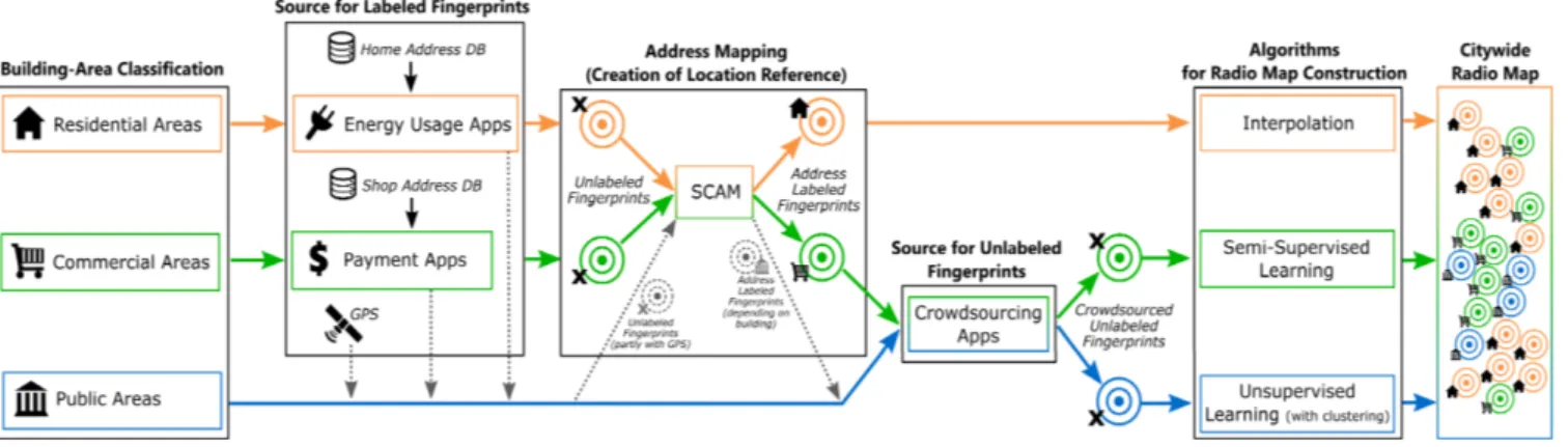
FIGURE 1. Schematic overview of the proposed citywide radio map.
III. METHOD
A. BUILDING TYPE CLASSIFICATION
One of the main contributions of this paper towards a city-wide indoor positioning system is the consideration of city building types and the subsequent variety of requirements for establishing an indoor radio map in these buildings. Current systems lack this kind of information owing to limitations such as tests done in a single environment e.g., one kind of building, or the use of different methods e.g., manual calibration, which we aim to avoid.
Buildings in a city are different from each other with respect to their architectures, interiors, and purposes. Depending on the purpose of a building and the way people interact within it, it is recommended that different meth-ods are applied for the location labeling of fingerprints for different buildings. However, when considering this for the establishment of an indoor positioning system, these unique buildings must be classified in a way that the system can provide a balance of accuracy and minimal calibration efforts. Furthermore, a building can be used for several purposes; for example, a car park in the basement used for parking, a market on the first floor used for shopping, and apartments on the floors above used for living. Thus, the classification should not be based on buildings themselves but rather on subareas of buildings to remain flexible towards multipurpose buildings. We propose differentiating the subareas of buildings in a city into the following three most representative categories:
• Residential areas of buildings • Commercial areas of buildings • Public areas of buildings
The primary criterion for this classification is based on the purpose of a particular area inside the building. Here, resi-dential areas include all areas that solely serve as someone’s home. People in residential areas are most likely interested in reaching a specific home and use the hallways purely as tran-sit space. Thus, highly accurate potran-sitioning is not necessary, and room-level accuracy can be targeted. Commercial areas are openly accessible areas that are mainly used for shop-ping or general transactions. By contrast to residential areas, hallways play a central role in commercial areas as people
occupy them for window shopping, resting, and interaction. Hence, high positioning accuracy is essential for hallways in commercial areas. Public areas are all other freely accessible areas that are not classified as commercial or residential and consist mainly of industrial areas and offices.
B. COLLECTION OF REFERENCE LOCATIONS
Based on the aforementioned building area classification, an appropriate method for the collection of reference loca-tions is assigned to each category. These methods are explained in detail in the following sections. Fig.1depicts an overview of the building classes and their respective reference location collection methods.
1) SOURCE OF REFERENCE LOCATIONS IN RESIDENTIAL AREAS
Addresses stored in external databases can be a suitable can-didate for the creation of reference locations by labeling col-lected fingerprints with these addresses. To enable the usage of addresses for this purpose, some kind of connecting feature between the gathered fingerprint at an unknown location and the external database must be utilized. In this case, mobile apps can serve as such a connection.
For residential areas, the usage of an energy usage-registering app, utilized by meter-readers to monitor the energy usages of clients, can be considered to provide the required collection of reference locations. We assume that the meter-readers visit a home to monitor its energy usage, such as electricity, water, or gas. The meter-readers enter the measured values into an app running on their smartphones. The reading and entering is usually conducted in front of or near the usage-registering instruments, which again are most likely located inside the house or apartment. Thus, when fingerprints are collected from a meter-reader’s smartphone, they can be considered as being collected from the home address stored in an external database of the energy company the app is connected with. By using these addresses for label-ing, the collected fingerprints can be stored in the address-labeled fingerprint database, which provides an initial radio map.
In some countries, advanced measurement instru-ments (AMIs) are used instead to measure energy usage such as automatic meter readers. Human meter-readers are thus not required, which is why a fingerprint collecting routine should be embedded into the AMI to ensure the collection of address-based reference locations.
2) SOURCE OF REFERENCE LOCATIONS IN COMMERCIAL AREAS
While an energy usage app can be used for the collection of reference locations in residential building areas, a mobile payment app is more suitable for collecting reference loca-tions in commercial areas. When a person enters a shop, e.g., in a shopping mall, and buys a product there, the payment is made at the cashier, which is most likely located within the shop. Furthermore, nowadays, payments are often conducted with mobile payment apps, which leads to the assumption that fingerprints gathered through a smartphone during a payment can be considered to be collected at the shop. Therefore, it is possible to use the address associated with the given shop, which will be located in an external database of the payment app company, for address-labeling of the collected fingerprints. These can then be stored in the address-labeled fingerprint database for the initial radio map. This method is not limited to shops as it can be utilized in any place where payments are conducted and an address is available, e.g., restaurants and bars.
As stated above, reference locations from payment apps are collected at the cashier desk in shops. However, the exact location of the payment desk in a shop is not always known, i.e., some shops have their payment desks in the front, some are located at the center, etc. Hence, assigning the reference locations in these environments to fixed locations is very inaccurate as payment desk location can vary between shops. Therefore, a location optimization algorithm is required to overcome this significant issue for efficient location-labeling. 3) SOURCE OF REFERENCE LOCATIONS
IN PUBLIC AREAS
Both energy usage-registering apps and mobile payment apps can also be used for the collection of reference locations in public buildings such as airport terminals, subway sta-tions, exhibition centers, universities, etc. However, in these environments, only a limited number of reference locations can be collected by such apps because the density of shops or energy usage gauging instruments is rather low in pub-lic buildings. Therefore, collecting GPS signals along with Wi-Fi signals can provide a rough clue of the reference locations. Additionally, by using the energy usage-registering and payment apps, the address of each place can be stored in the address-labeled fingerprint database. This should be seen as a building-sharp identification to distinguish different buildings from each other and to create an initial, limited starting point for constructing a radio map. However, refer-ence locations do not play a major role in radio map con-struction in public areas due to the limited number of possible
reference points, which is why an unsupervised method is used to construct the radio maps.
4) SIMULTANEOUS CALIBRATION AND ADDRESS MAPPING (SCAM)
The previous sections showed that when a mobile application is capable of collecting an address and fingerprints simultane-ously, it can provide an opportunity for mapping the collected fingerprints into an address to create reference locations. We call the mapping of a fingerprint into an address collected from a mobile application a simultaneous calibration and
address mapping (SCAM) in this paper. In addition, if a
mobile application allows SCAM, we call it a SCAM transac-tion. Although no SCAM transactions are currently available, many mobile applications can be transformed into SCAM transactions by simply embedding a fingerprint collecting routine. This applies not only to the previously mentioned applications but to any application that can collect an address and fingerprints simultaneously, such as online shopping apps and delivery service apps.
C. RADIO MAP CONSTRUCTION
After deriving reference locations from the aforementioned sources, the next step is to construct the radio maps for each building subarea category.
1) RADIO MAP CONSTRUCTION FOR RESIDENTIAL AREAS In an ideal scenario, energy usage-registering apps could collect reference locations at most homes in residential areas in collaboration with energy meter-readers. Note that in some countries, meter-readers must visit each home periodically to measure its energy usage or to check for leakage of gas, water, or electricity, which can be seen as updates on the reference locations. In a case where a remote sensor measures energy usage, we assume that a module to collect reference locations has already been embedded into the sensor.
Radio maps for residential areas can be constructed using an interpolation technique for the reference locations because homes are located separately and at regular distances from each other, especially in high-rise apartments. Outdoor as well as indoor radio maps can be constructed by interpolating the collected reference locations. Outdoor radio map con-struction is somewhat different from its indoor counterpart because it must be constructed on 2D ground from reference locations collected in 3D space. For indoor radio map con-struction, however, the reference locations are expected to be collected at each floor of the building. High-rise apartment buildings are a classic example in such an approach. In South Korea, this kind of housing accounts for the largest share among housing styles, with a total share of 60.6% of all housing units in 2017 [19]. Therefore, especially for this kind of residential building (but also for relatively dense detached house areas), interpolation techniques can be con-sidered as a fast and sufficiently efficient radio map algorithm strategy [20].
FIGURE 2. Radio map construction process from HMM modeling. A wide range of interpolation techniques are available, such as linear, inverse distance weighting (IDW), and Krig-ing interpolation [21], [22]. However, this study utilizes the IDW interpolation method because it considers all reference locations when creating interpolated values. Another major benefit of using IDW is that it explicitly assigns more weight to the reference points that are closer to the point being pre-dicted. This means that IDW works under the assumption that the reference points close to each other are more dependent on each other compared to the points that are far away. This assumption is very beneficial for predicting geolocation coor-dinates. The collected sample fingerprints serve as reference point inputs for IDW, which then can predict an interpolated value at any point in the environment.
Meanwhile, there are several approaches available to assign a precise location to an address-labeled fingerprint. One is to set the location to the center of a building because the exact location at which wireless signals are scanned is usually unknown. This would be the most inaccurate way and should be avoided for large buildings. Another approach is to set the collected location to the installed location of the energy usage gauge, which is specified in the CAD files of energy pipelines maintained by energy companies. Addition-ally, the floor and room number are often given in the address, which can be used in combination with floor plans to estimate the location more accurately.
2) RADIO MAP CONSTRUCTION FOR COMMERCIAL AREAS
In commercial areas, reference locations can be collected from almost every shop through the aforementioned collab-oration of mobile payment apps. If a fingerprint collection module is embedded in a mobile payment app and it derives fingerprints during a payment session in a shop, these col-lected fingerprints can be labeled with the shop’s address and stored in the databases of the payment companies. By con-tinuing this procedure for all shops in the commercial area of a building, the whole environment can be covered with fingerprints.
However, commercial and residential areas of a building differ in the use of navigation space, particularly in hallways.
People stay longer in hallways for shopping or resting in commercial areas than they do in residential areas, which is why the positioning service in hallways is critical in these environments and so is the construction of radio maps in hallways. Thus, owing to the higher number of available reference locations and the demand for more accurate posi-tioning, a semi-supervised location-labeling method is used for the construction of radio maps in commercial areas. It is proposed that the semi-supervised location-labeling method uses address-unlabeled crowdsourced fingerprints collected from various location-based service applications as its train-ing data.
Nevertheless, the semi-supervised location-labeling method should be adaptive to use the address-labeled fin-gerprints for its reference locations. This is because the exact locations from which fingerprints have been collected in a shop are unknown, with only the address information obtained through the payment. Cashier desks can be located anywhere within a shop’s space. When a shop is large, serious performance degradation of the learning may be seen. To address this challenge, we use the method proposed in our previous paper [23]. This method is an efficient semi-supervised location-labeling method for fingerprints that uses address-labeled fingerprints for its reference locations. In this method, the reference locations can be associated with many points in the shops they have been collected from. A summary of the method is given below.
Fig.2shows the process of constructing radio maps with the reference locations and crowdsourced fingerprints. Ini-tially, only the locations of fingerprints collected by cashiers inside shops are known, and they are represented with red dots in the leftmost block. The inner structure of a building is modeled by the topology of a hidden Markov model (HMM) (step 1). More specifically, a floorplan image is converted into the HMM topology, where a location is represented as a state and the geographic accessibility between locations is represented as transitions. The finger-print sequences are considered as observation sequences from the HMM. Voronoi-tessellation and Lloyd’s relaxation are used to divide the area equally. The area is partitioned into coarsely grained (10×10m2) and fine-grained (4×4m2) areas.
However, as explained earlier, in commercial areas, local-ization in hallways is important because of their frequent use. An initial radio map that covers hallways is constructed in the next step by applying interpolation on the reference locations (step 2).
It is important to determine the optimal locations of cashier desks inside the shops instead of assuming random posi-tioning for better accuracy. The genetic algorithm is used to find an optimal placement of labeled fingerprint sequences; it starts its process from the creation of a chromosome and a population. First, a random position is selected, which is known as a chromosome, and each loss value is calculated. In this way, many radio maps are constructed in a single generation. For the next generation, the genetic algorithm references the location with the smallest loss value by the crossover method. The next time, the locations with the small-est loss values are generated, and the accuracy continues to improve. Once the locations of address-labeled fingerprints, which form the chromosome of the genetic algorithm, are set at each shop, a radio map is constructed through interpolation using the location-fixed fingerprints. IDW is used for the generation of radio maps because of its simplicity [21]. The initial radio map of hallways is represented by green dots in Fig.2(step 2).
After constructing the initial radio map, the method uti-lizes the numerous available unlabeled crowdsourced finger-prints to increase the overall accuracy (step 3). This step, where the unlabeled fingerprints are placed at the appropriate locations, is the most critical step in the whole procedure. As the positioning services provide the unlabeled data, they are usually in sequential form. These sequential fingerprints are labeled using the HMM with the forward backward algo-rithm. The forward backward algorithm calculates the pos-terior marginals of the most likely state at a particular time. The main reason for using the forward backward algorithm is that we cannot model all states, such as the transitions between floors, restrooms, and shops from inside. The large (10 × 10m2) modeling is used for the labeling of crowd-sourced fingerprints because it is computationally less costly. Consequently, the sequences of unlabeled fingerprints are placed as shown by orange, yellow, and blue lines in Fig.2 (step 3). However, it is not possible to provide good accu-racy with such large modeling, so (4 × 4m2) is utilized for positioning.
To avoid the limitation due to the volume of available training data, an objective function is defined to determine the quality of the configurations of reference locations. This loss function analyzes the distance of consecutively scanned fingerprints for the evaluation. The genetic algorithm repeats from step 2 to step 4, changing its initial population until it finds an optimal placement (step 5). A complete final radio map is obtained by the end of this procedure.
3) RADIO MAP CONSTRUCTION FOR PUBLIC BUILDINGS A large number of reference locations can be collected from buildings in residential and commercial areas, whereas only a
limited number of reference locations can be collected in pub-lic buildings via collaboration with payment apps or energy usage measuring apps. Therefore, radio map construction for public buildings with the crowdsourced fingerprints is much more challenging.
An unsupervised location-labeling method should be used for the construction of radio maps for public buildings. There-fore, an unsupervised learning method titled ‘‘Unsupervised Calibration based on a Memetic Algorithm (UCMA),’’ is uti-lized here. This algorithm estimates the collected locations of crowdsourced fingerprints without reference locations [17]. In UCMA, a global-local hybrid optimization algorithm esti-mates the placement of the fingerprint sequences that best fits into the topology of a building. The local optimization in the hybrid optimization algorithm adopts the strategy of unsu-pervised HMM training, which estimates the model param-eters of a HMM using an expectation-maximization (EM) algorithm given unlabeled data [25]. A likelihood function R Pr(U, P|λ) is used simultaneously to evaluate a set of estimated model parameters and for placement of unlabeled fingerprint sequences, where U is a fingerprint sequence set, P is the placement, andλ is a set of estimated HMM model parameters.
λ =< π, A, B >
whereπ is an initial probability distribution on the location-states, A is a transition probability matrix that represents how a person moves in a building with the stairs, eleva-tors, and walls, and B is the set of emission probabilities, which provide the likelihood of an observation at a specific point.
EM-style algorithms for HMM training take a local search approach [24]. Hence, these methods often get stuck in local optima, especially when dealing with a complex prob-lem like the location-labeling of fingerprints. To deal with this problem, a good initial guess of HMM parameters is required as a starting point of the training. We can gen-erate an initial estimate using address-labeled fingerprints. The location of each address-labeled fingerprint is con-verted into a specific point in the corresponding shop. The initial estimate may not be a good choice in some situa-tions, especially when the sizes of shops are not sufficiently small. A population-based evolutionary search algorithm is responsible for finding a reasonable initial estimate. This so-called global search algorithm iteratively improves the initial guesses and makes improvements to the local optimization. The global search and local optimization algorithms are inte-grated into a memetic algorithm, which is an evolutionary approach, providing an efficient way to solve optimization problems through the interaction between global and local optimization.
IV. EXPERIMENTS AND RESULTS
We constructed radio maps using the proposed techniques to evaluate the effectiveness of the proposed radio map con-struction method.
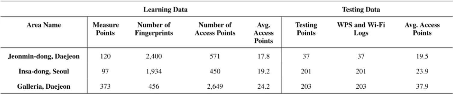
TABLE 1. Statistics of learning and testing data in residential areas.
A. RESIDENTIAL AREAS
Radio maps for residential areas were constructed in the cities of Seoul and Daejeon. Although mobile payments are effec-tive in collecting reference locations in commercial areas, they cannot be used in residential areas because only few shops are located in residential areas. The reference locations in residential areas can be collected from the smartphones of meter-readers who are supposed to visit each home.
Over one hundred energy usage meter-readers who visit each home to check its energy usage collected the training samples for 3 months. We validated the effectiveness of collecting address-labeled fingerprints using another SCAM transaction, energy usage measurement, in one residential area in Seoul and two in Daejeon, Korea. Insa-dong, Seoul is mostly occupied by traditional single- or low-story houses. The area features narrow meandering roads connecting small houses. Jeonmin-dong, Daejeon is a residential area with four-story small-scale group houses with well-planned grid structure roads. The houses are located in a complex region and there exist medium-scale parking areas between the buildings.
Training data were collected by collectors who visited each home in the study areas. Approximately 19,000 Wi-Fi fingerprints were collected from approximately 1,000 points in total. The testing data, including Google Wi-Fi positioning system (WPS) logs and Wi-Fi logs, were also separately col-lected for the evaluation. The training samples were mostly collected indoors, whereas the testing data were collected both indoors and outdoors. This explains why the average number of access points of the test data was slightly larger than that of the learning data.
The radio maps were constructed without variation of the locations of address-labeled fingerprints at each home. This is because the primary purpose of the experiment was to test whether each home could be detected with the radio map constructed by the labeled fingerprints and address-unknown crowdsourced fingerprints. Thus, when the predic-tion was correctly, the error distance was set to zero in the evaluation.
The positioning accuracy was measured using K nearest neighbour(KNN) with K = 3 and was approximately 5-10 m on average in Daejeon and Seoul. The accuracy was approx-imately 5 m when the collection rate was 100%, whereas
the accuracy was approximately 10 m when the collection rate was 50%. A collection rate of 100% means that the training samples were collected from every home, whereas a collection rate of 50% means that the training samples were collected from every other home.
The ground truths of the testing data were confirmed by manually marking the testing points on physical maps. Table1 summarizes the collected learning and testing data. The accuracy was greatly improved compared to that of Google
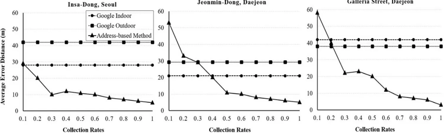
WPS, whose accuracy was approximately 20-40 m both indoors and outdoors. This improved accuracy allows us to locate a particular house in an apartment building or a detached house area with over 90% probability using a finger-print obtained at the house. Fig.3shows that the positioning accuracy improved with incremental increases in the number of collected fingerprints in each area.
B. COMMERCIAL AREAS
Radio maps for commercial areas were constructed for three landmark buildings in Seoul: COEX, Lotte World, and Times Square. COEX is Asia’s largest underground shopping mall and contains three five-star hotels, one 55-story and one 41-story premier office tower, a large department store, a sub-way station, and more. Lotte World contains underground shopping malls and an indoor amusement park in the tallest building in Asia with 123 stories. Approximately 2000 APs, with most of their locations unknown, had already been installed in each landmark building. Times Square is one of the biggest indoor shopping malls in Korea and contains a large-scale discount store, a large department store, and a CGV Starium. The COEX Mall is located in basement B1F and has an area of 630 × 300m. Lotte World Mall and Times Square Mall are both located on the first floor 1F and they have areas of 400 × 180m and 320 × 1800m, respectively.
A mobile wallet application was used for the collection of address-labeled fingerprints for six months. The app, which already has the address information of shops, was down-loaded by more than one million users. Approximately five thousand fingerprints were filtered from the crowdsourced fingerprints for the training at each building. The testing samples were collected manually at the buildings, confirming
FIGURE 3. Average error distances vs. Google WPS.
TABLE 2. Summary of data collected from the COEX, Lotte world, and times square buildings.
their ground truth locations. Also, the reference locations were collected at the shops in the test areas simulating offline mobile payment. Collectors visited shops in the test areas to collect reference locations. The Samsung S6 was used for the collection of the testing samples and reference locations.
Table 2 summarizes the training and testing samples collected for evaluation at the COEX, Lotte World, and Times Square buildings. KNN was used with K = 3 to measure the accuracy of radio maps in commercial areas. The accuracies measured on radio maps for the COEX, Lotte World, Times Square buildings were 6.8 m, 7.2 m, and 7.1 m, respectively. The accuracies improved from approximately 10 m to 7 m with increasing training samples as shown in Fig. 4. The radio maps were con-structed with the reference locations and unlabeled finger-prints collected from shops and hallways. The radio maps were constructed by the proposed semi-supervised location-labeling method. The effect of adjusting reference locations at each shop for the method was apparent. The adjust-ment of reference location positions improved the results by approximately 30%.
FIGURE 4. Accuracy improvement with increasing training samples at the COEX, Lotte world, and times square buildings.
C. PUBLIC AREAS
The efficiency of the proposed unlabeled location-labeling method was evaluated under various scenarios. The exper-iments were conducted in a large-scale office building at the Korea Advanced Institute of Science and Technol-ogy‘(KAIST), Daejeon, Korea, called the N1 testbed, and the KI building, in Shenzhen, Guangdong, China. Both energy usage measuring apps and payment apps were used to collect the Wi-Fi dataset with reference locations, and a mobile crowdsourcing app was used to collect the unlabeled data.
N1 testbed building has an area of 75 m ×22 m, and the KI building has an area of 120 m × 35 m. The N1 building and KI building each have two staircases and four elevators. The length and width of corridors in N1 are 194 m and 3 m, respectively, and those in the KI building are 291 m and 6.5 m, respectively.
Unsupervised learning is possible only with a sufficient number of training samples: approximately 5,000 training samples in this case. In addition, the learning has a high computational time complexity. The time complexity is lin-early proportional to the number of samples. Other factors are the number of generations and the segmental K-means (SK) local optimization algorithm. An advantage of using SK local
FIGURE 5. Effect of changing the amount of training data on supervised and unsupervised learning in N1.
optimization is that it does require any data reduction pro-cedure as it can effectively handle innumerable RSS values through a pre-processed distance matrix. Another important feature of UCMA is the learning convergence. Some param-eters, such as number of generations and population size, can affect the convergence process, and both of them were set to 100 via a conventional parameter setting approach. It took approximately one hour for a PC to construct the radio map on testbed N1. The PC used for the implementation had 8 GB of memory and a 3.40 GHz processor, and all implementation was done in Java.
Evaluation in public areas was done using KNN with K = 1. The positioning accuracy measured on the N1 testbed by UCMA was approximately 4-5 m as shown in Fig. 5. Although the radio map was constructed by the unsuper-vised location-labeling method, the positioning accuracy was comparable to the accuracy of 3-4 m achieved by manual calibration.
The positioning accuracy achieved in the KI building was 9-12 m. There are strong reasons why UCMA could not give good accuracy in the KI building compared to the N1 testbed. The KI building size is much larger than the N1 testbed size, and the width of corridors in the KI building is much higher, which results in poor accuracy. In addition, the Wi-Fi dataset collected in the KI building for the training of UCMA was not sufficient for the convergence of UCMA learning. Therefore, the KI AP environment is not as good as that of the KAIST N1 building. The AP environment was not strong in the test area of UCMA, which is a valid reason for this accuracy. Table3provides a comparison of UCMA results in the N1 testbed and KI building.
The problems raised in the KI building can be solved by extending the UCMA so that it can utilize stair and elevator reference locations whenever they are avail-able. The original UCMA is still necessary because we cannot expect all buildings to provide their stair and ele-vator information to fingerprints collected in the build-ings. However, if we want to make radio maps using only Wi-Fi signals with unsupervised learning, sufficient data and the presence of a reasonable AP environment are mandatory.
TABLE 3.Comparison of UCMA evaluations for the KAIST N1 testbed and the KI building.
V. DISCUSSION
The experiments conducted on different building structures proved that the proposed method can be used to construct radio maps of most buildings in cities without the need for manual calibration. This research also suggests the most suit-able crowdsourcing methods for each area, and the datasets for each of the three area types were collected through the proposed crowdsourcing techniques. The achieved accuracy in all three area types proves that a global indoor localization service can be provided using only crowdsourced data.
The average error distance in residential areas was 5-10 m and was compared with Google indoor and outdoor WPS. The accuracy of Google WPS, especially indoors, was inficient, as opposed to our proposed method, which gave suf-ficient accuracy. The proposed method could identify homes individually in multi-story apartment buildings. The selected buildings for evaluation in commercial areas were chosen with great care as all three of them provide distinct archi-tectures and scenarios. In all three commercial buildings, the width of hallways is 15 m and the average accuracy achieved by the proposed method is 6-7 m, which is appro-priate. UCMA was proposed for public areas because it is not feasible to collect reference locations in public buildings through crowdsourcing. This is why only a small number of reference locations were collected in public areas by using energy usage measuring and payment apps; hence, we still call it unsupervised learning because the amount of labeled data was ignorable and training of UCMA was done solely with unlabeled data. However, one problem with the unsu-pervised approach is that it is time consuming; however, this approach uses only an unlabeled Wi-Fi dataset and still gives adequate results in buildings like the N1 testbed.
In Section 2.3, previous methods for reducing the calibra-tion effort in the indoor posicalibra-tioning field were discussed, but these methods focus only on one type of building architecture. This work is distinguished from other works because it pro-vides a precise indoor positioning service with crowdsourced fingerprints in residential areas, commercial areas, and public areas. This paper suggests the most suitable approaches to constructing radio maps for three types of areas in a city using only crowdsourced data. Nevertheless, unlike the GPS, which has matured, the global indoor positioning system (GIPS) is still in its infancy. SCAM and the proposed location-labeling methods are opening a new horizon for the GIPS, giving new vitality to discarded fingerprints. The proposed methodology provides the potential of constructing radio maps at a city or even at a country level.
In fact, the areas in a city can be categorized into three rep-resentative areas: residential, commercial, and public. How-ever, not all buildings in a city can be covered. The proposed method does not cover the buildings that fall into a combina-tion of areas. In addicombina-tion, in this study, we did not focus on constructing outdoor radio maps.
Although the proposed method’s effectiveness has been proved through many experiments, the cooperation of energy and payment companies is indispensable in accomplishing this goal. It has also been confirmed that the precision of radio maps can be further improved by the proposed location-labeling method utilizing crowdsourced fingerprints and address-labeled fingerprints collected by SCAM. The method requires indoor space modeling based on indoor maps, which are not available yet for many buildings. There-fore, the method can only be used for buildings whose indoor maps are available. Fortunately, the number of buildings whose indoor maps are available on the Internet is currently rapidly growing.
VI. CONCLUSION
City radio maps provide the basis for a citywide indoor positioning service. Crowdsourcing of fingerprints and location-labeling of crowdsourced fingerprints are required to construct a city radio map without manual calibrations. It transpired that a city radio map could be constructed more effectively by applying appropriate radio map construction techniques depending on the category of buildings.
In residential areas, an energy usage-registering app is a good means of collecting reference locations. An interpola-tion technique allows us to construct a more precise radio map with the reference locations. In commercial areas, a mobile payment app is a good way to collect reference locations. A semi-supervised location-labeling method can be used to construct radio maps covering hallways. Despite only being able to collect a limited number of reference locations in public buildings, radio maps can still be constructed for pub-lic buildings by extending the unsupervised location-labeling method.
This work provides a precise indoor positioning service with crowdsourced fingerprints for all areas. An accuracy
of 10 m was achieved in four residential areas, which is acceptable because homes could be located on the con-structed radio maps. The accuracy of 6-7 m achieved by the proposed method at the three landmark buildings was acceptable because the widths of the hallways of the buildings were approximately 15 m on average. The accuracy of 4-5 m achieved in a university building was also sufficient.
If SCAM transaction applications become popular and have many users, a huge number of address and fingerprint pairs can be collected in a short time span without any additional costs. Eventually, the mass of collected address and fingerprint pairs will be an invaluable source of build-ing address-based radio maps for most buildbuild-ings in a city, a nation, or all over the world.
In this paper, energy usage-registering apps and payment apps were proposed to collect data for residential and com-mercial areas, respectively. In this era of smart systems and technology, the usage of payment apps is rising and will increase further in the future. However, the system-level problems, such as power consumption and security are outside the scope of this study. This paper emphasizes and proposes revolutionary ideas for integrating new apps in the field of crowdsourcing of mobile signals. Separate research is required to investigate these details. After proving the practi-cality of these apps in city radio map construction, the system-level issues will be explored in our next study. Our proposed method constructs radio maps using only anonymous data. Thus, privacy is not a matter.
ACKNOWLEDGMENT
This work was partially supported by the National Research Foundation of Korea (NRF) grant funded by the Korea gov-ernment (MSIP) (No. 2018R1A2A1A05078018), Institute of Information & communications Technology Planning & Evaluation (IITP) grant funded by the Korea gov-ernment (MSIT) (No. 20180002380021001), and the Center for Integrated Smart Sensors funded by the Ministry of Science and ICT as Global Frontier Project (CISS-2012M3A6A6054195).
REFERENCES
[1] A. Vanclooster, N. V. de Weghe, and P. De Maeyer, ‘‘Integrating indoor and outdoor spaces for pedestrian navigation guidance: A review,’’ Trans. GIS, vol. 20, no. 4, pp. 491–525, Aug. 2016.
[2] Y. Liu and Q. Chen, ‘‘Research on integration of indoor and outdoor positioning in professional athletic training,’’ Proceedings, vol. 2, no. 6, p. 295, Feb. 2018.
[3] K. Zhang, C. Shen, Q. Zhou, H. Wang, Q. Gao, and Y. Chen, ‘‘A combined GPS UWB and MARG locationing algorithm for indoor and outdoor mixed scenario,’’ in Proc. Cluster Comput., Jan. 2018, pp. 1–10.
[4] H. Liu, H. Darabi, P. Banerjee, and J. Liu, ‘‘Survey of wireless indoor positioning techniques and systems,’’ IEEE Trans. Syst., Man, Cybern. C, Appl. Rev., vol. 37, no. 6, pp. 1067–1080, Nov. 2007.
[5] J. Xu, C. Gong, and Z. Xu, ‘‘Experimental indoor visible light positioning systems with centimeter accuracy based on a commercial smartphone camera,’’ IEEE Photon. J., vol. 10, no. 6, Dec. 2018, Art. no. 7908717. [6] L. W. Chen, T. P. Chen, D. E. Chen, J. X. Liu, and M. F. Tsai, ‘‘Smart
cam-pus care and guiding with dedicated video footprinting through Internet of Things technologies,’’ IEEE Access, vol. 6, pp. 43956–43966, 2018.
[7] J. Zuo, S. Liu, H. Xia, and Y. Qiao, ‘‘Multi-phase fingerprint map based on interpolation for indoor localization using ibeacons,’’ IEEE Sensors J., vol. 18, no. 8, pp. 3351–3359, Apr. 2018.
[8] S.-H. Jung, S. Lee, and D. Han, ‘‘A crowdsourcing-based global indoor positioning and navigation system,’’ Pervasive Mobile Comput., vol. 31, no. 6, pp. 94–106, Sep. 2016.
[9] X. Du and K. Yang, ‘‘A map-assisted WiFi AP placement algorithm enabling mobile device’s indoor positioning,’’ IEEE Syst. J., vol. 11, no. 3, pp. 1467–1475, Sep. 2017.
[10] H. Zou, M. Jin, H. Jiang, L. Xie, and C. J. Spanos, ‘‘WinIPS: WiFi-based non-intrusive indoor positioning system with Online radio map construction and adaptation,’’ IEEE Trans. Wireless Commun., vol. 16, no. 12, pp. 8118–8130, Dec. 2017.
[11] Y. Zhuang, Z. Syed, Y. Li, and N. El-Sheimy, ‘‘Evaluation of two WiFi positioning systems based on autonomous crowdsourcing of handheld devices for indoor navigation,’’ IEEE Trans. Mobile Comput., vol. 15, no. 8, pp. 1982–1995, Aug. 2016.
[12] P. Bolliger, ‘‘Redpin—Adaptive, zero-configuration indoor localization through user collaboration,’’ in Proc. 1st Int. Workshop Mobile Entity Localization Tracking GPS-Less Environ., Sep. 2008, pp. 55–60. [13] B. Lashkari, J. Rezazadeh, R. Farahbakhsh, and K. Sandrasegaran,
‘‘Crowdsourcing and sensing for indoor localization in IoT: A review,’’ IEEE Sensors J., vol. 19, no. 7, pp. 2408–2434, Apr. 2019.
[14] H. Wang, S. Sen, A. Elgohary, M. Farid, M. Youssef, and R. R. Choudhury, ‘‘No need to war-drive: Unsupervised indoor localization,’’ in Proc. 10th Int. Conf. Mobile Syst., Appl., Services, Jun. 2012, pp. 197–210. [15] Z. Yang, C. Wu, and Y. Liu, ‘‘Locating in fingerprint space: Wireless indoor
localization with little human intervention,’’ in Proc. 18th Annu. Int. Conf. Mobile Comput. Netw., Aug. 2012, vol. 12, pp. 269–280.
[16] A. Rai, K. K. Chintalapudi, V. N. Padmanabhan, and R. Sen, ‘‘Zee: Zero-effort crowdsourcing for indoor localization,’’ in Proc. 18th Annu. Int. Conf. Mobile Comput. Netw., Aug. 2012, vol. 12, pp. 293–304. [17] S.-H. Jung, B.-C. Moon, and D. Han, ‘‘Unsupervised learning for
crowd-sourced indoor localization in wireless networks,’’ IEEE Trans. Mobile Comput., vol. 15, no. 11, pp. 2892–2906, Nov. 2016.
[18] M. Zhang, L. Pei, and X. Deng, ‘‘GraphSLAM-based Crowdsourcing framework for indoor Wi-Fi fingerprinting,’’ in Proc. 4th Int. Conf. Ubiq-uitous Positioning, Indoor Navigat. Location Based Services (UPINLBS), Nov. 2016, pp. 61–67.
[19] S. Korea, ‘‘2017 Population and housing census,’’ Tech. Rep., 2017. [20] J. Y. Zhu, A. X. Zheng, J. Xu, and V. O. K. Li, ‘‘Spatio-temporal (S-T)
similarity model for constructing WIFI-based RSSI fingerprinting map for indoor localization,’’ in Proc. Int. Conf. Indoor Positioning Indoor Navigat. (IPIN), Oct. 2014, pp. 678–684.
[21] S.-P. Kuo and Y.-C. Tseng, ‘‘Discriminant minimization search for large-scale RF-based localization systems,’’ IEEE Trans. Mobile Comput., vol. 10, no. 2, pp. 291–304, Feb. 2011.
[22] D. Mao, W. Shao, Z. Qian, H. Xue, X. Lu, and H. Wu, ‘‘Constructing accurate radio environment maps with Kriging interpolation in cognitive radio networks,’’ in Proc. Cross Strait Quad-Regional Radio Sci. Wireless Technol. Conf. (CSQRWC), Jul. 2018, pp. 1–3.
[23] J. Ahn and D. Han, ‘‘Crowd-assisted radio map construction for Wi-Fi positioning systems,’’ in Proc. Int. Conf. Indoor Positioning Indoor Navigat. (IPIN), Sep. 2017, pp. 1–8.
[24] R. Dugad and U. B. Desai, ‘‘A tutorial on hidden Markov models,’’ Signal Process. Artif. Neural Netw. Lab., Dept Electr. Eng., Indian Inst. Technol., Mumbai, India, Tech. Rep. SPANN-96.1, 1996.
[25] B.-H. Juang and L. R. Rabiner, ‘‘The segmental K-means algorithm for estimating parameters of hidden Markov models,’’ IEEE Trans. Acoust., Speech, Signal Process., vol. 38, no. 9, pp. 1639–1641, Sep. 1990.
DONGSOO HAN received the Ph.D. degree in information science from Kyoto University. He is currently a Professor of computer science with the Korea Advanced Institute of Science and Technology (KAIST). He is also the Director of the Indoor Positioning Research Center, KAIST. His research interests include indoor positioning, pervasive computing, and location-based mobile applications.
AYESHA SAHAR received the B.S. degree in computer engineering from the University of Engineering and Technology (UET) at Lahore, Pakistan, in 2017. She is currently pursuing the master’s degree in computer science from the Korea Advanced Institute of Science and Technol-ogy. Her research interests include wireless indoor positioning, mobile signal applications, machine learning, and deep learning.
JOSEPH BERKNER received the master’s degree in geodesy and geoinformation science from Tech-nische Universität Berlin. He is currently pursu-ing the Ph.D. degree with the Korea Advanced Institute of Science and Technology (KAIST). His research interests include sensorless localization, GIS, and data visualization.
GUNWOO LEE received the M.S. degree in com-puter science and engineering from Chung-Ang University, Seoul, South Korea. He is currently pursuing the Ph.D. degree in computer science with the Korea Advanced Institute of Science and Technology, Daejeon, South Korea. His research interests include computer networks, indoor posi-tioning, and machine learning and their applica-tions in pervasive computing.
![FIGURE 2. Radio map construction process from HMM modeling. A wide range of interpolation techniques are available, such as linear, inverse distance weighting (IDW), and Krig-ing interpolation [21], [22]](https://thumb-ap.123doks.com/thumbv2/123dokinfo/5089288.76487/5.864.64.805.102.311/construction-modeling-interpolation-techniques-available-distance-weighting-interpolation.webp)