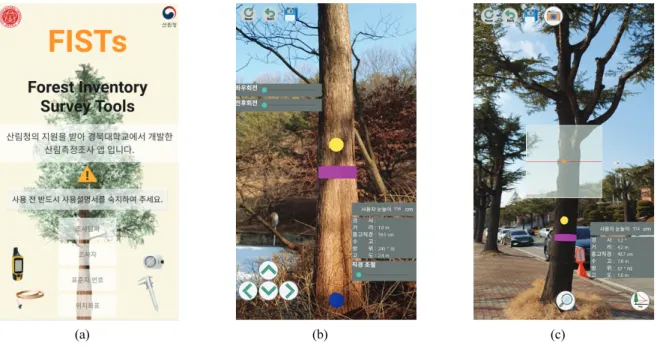
수고 및 흉고직경 측정 스마트폰 애플리케이션 개발
김동현
1⋅김선재
2⋅성은지
2⋅김동근
1*1
경북대학교 생태환경시스템학과,
2경북대학교 소트프웨어학과
Development of a Smartphone Application for the Measurement of
Tree Height and Diameter at Breast Height
Dong-Hyeon Kim
1, Sun-Jae Kim
2, Eun-Ji Sung
2and Dong-Geun Kim
1*1
Department of Ecology and Environment System, Kyungpook National University, Sangju 37224, Korea
2Department of Software, Kyungpook National University, Sangju 37224, Korea
요 약: 본 연구는 다양한 임목 정보를 측정하고 효과적으로 관리하기 위해 스마트폰 애플리케이션과 웹 애플리케이션 서 버(Web Application Server, WAS)를 개발하였다. 수고, 방위, 고도, 경사, 위치 좌표는 스마트폰에 내장된 동작센서를 통해 취득된 각도를 삼각법에 적용하여 측정하였으며, 흉고직경 및 거리는 Google AR Core에서 제공하는 AR API(Application
Programming Interface)를 응용하여 측정할 수 있도록 하였다. 웹 애플리케이션 서버는 스마트폰이 측정한 데이터를 수신 하여 저장, 조회, 출력하고 수목의 위치를 카카오 맵에 표시할 수 있도록 개발하였다. 또한, 개발된 애플리케이션의 정확성 을 평가하기 위해 인공 침엽수림에서 잣나무 90본, 천연 혼효림에서 무작위로 90본을 선정하여 버텍스 및 윤척과 비교하 였다. 비교 결과, 흉고직경과 수고 모두 95% 수준에서 유의한 결과를 나타내었으며, 흉고직경의 경우 인공 침엽수림이 평 균 0.6745 cm, 천연 혼효림에서는 평균 1.0139 cm의 오차를 보였다. 수고는 인공 침엽수림이 평균 0.6714 cm, 천연 혼효 림은 평균 1.3297 m의 오차를 보였다.
Abstract: We developed smartphone application and web application server to acquire and effectively manage tree measurement information. Smartphone applications can measure tree height, diameter at breast height (DBH), azimuth, altitude, slope, and positional coordinates using augmented reality (Google AR core) and motion sensors. The web application server effectively manages and stores measurement information. To evaluate the accuracy of information acquired using a smartphone, 90 Korean pine trees (Pinus koraiensis) were randomly selected from a natural mixed forest, with a total of 90 representative trees randomly collected from a natural mixed forest. Then, height and DBH were measured using a Haglof Vertex Laser Hypsometer and caliper. Comparisons of the results indicated significant results at the 95% level and a very high average correlation of 0.972 for both tree height and DBH. In terms of DBH, the average errors were 0.6745 cm and 1.0139 cm for artificial coniferous and natural mixed forests, respectively.
Key words: augmented reality, DBH, motion sensor, smartphone, tree height
서 론
1)
임목의 수고와 흉고직경은 산림 바이오매스, 탄소 축적 량, 생장 및 임분 생산성의 정량적 평가에 활용되는 중요 한 변수이며(Bijak and Sarzyński, 2015; Wu et al., 2019;
Fan et al., 2019), 수목의 상대 생장 관계 분석에도 사용된
* Corresponding author E-mail: [email protected] ORCID
Dong-geun Kim https://orcid.org/0000-0002-9841-1187
다(Kitahara etl al., 2010; Wu et al., 2020). 이를 조사하는 방법은 윤척, 하이트메타 등을 포함한 다양하고 단순한 측 정 장비를 사용하며, 조사결과를 야장에 기입 후, 내업을 하는 이원적인 환경을 가진다. 이러한 작업환경을 개선하 고자 비용, 노동력, 시간 등을 최소화하기 위한 다양한 연 구가 진행되고 있다.
최근 4차 산업혁명의 5대 핵심기술인 ICBMA (IoT, Cloud Computing, Big data, Mobile, AI) 기술이 의학, 공학, 농업, 임업 등 전 분야에서 다양하게 활용되고 있다. 특히 모바 일 기술이 급성장함에 따라 스마트폰을 임업 분야에 적용
JOURNAL OFKOREANSOCIETY OFFORESTSCIENCE
ISSN 2586-6613(Print), ISSN 2586-6621(Online)
http://e-journal.kfs21.or.kr
Bijak and Sarzyński, 2015; Itoh et al., 2010)와 같이 크게 2가지 주제로 구분되어 수행되고 있다. 이미지를 활용한 임목측정 연구는 스마트폰 출력 이미 지를 컴퓨터 비전 기술에 적용하여 임목의 수고, 수관 폭을 추정하거나, 수관이 겹치는 부분을 효과적으로 분 리하는 알고리즘 개발에 관한 연구가 많이 수행되었다
(Han and Dong, 2011). 이 방법은 조사 방법이 간편하고,
효율적이며 분석에 필요한 자료가 단순하므로 측정에 필 요로 하는 노동력이 적다는 장점이 있다. 그러나 국내 산림환경은 개체목의 완벽한 이미지를 취득하기에 지형, 수형 등과 같은 장애 요소가 많다. 이를 극복하고자 흉고 부위만을 촬영하여 수고를 추정하는 연구가 수행된 바 있으나(Vastaranta et al., 2015), 정확성이 떨어지는 단점 이 있다. 동작 센서를 활용한 임목측정 연구는 삼각함수의 원리 를 이용해 임목의 수고를 측정하는 연구가 주로 수행되었 는데, 이는 이미지 연구에 비해 노동력과 시간 소요가 많 으나 비교적 정확도가 높은 수고 추정이 가능하다는 이점 이 있다. Villasante and Fernadez(2014)는 Blume Leiss 및 Vertex IV와 Samsung Galaxy Note로 얻은 측정 오류를 비교ㆍ분석했다. 조사결과 RMSE의 오차범위가 0.63 – 0.86 m로 나타남으로써 스마트폰이 높은 측정 정확도를 나타내었다. 또한, Fan et al.(2020)은 스마트폰 종류에 따 른 센서 정확도는 각각 다르므로 이를 통일 시키기 위해 센서박스(GPS, 자이로스코프 등)를 스마트폰에 부착하여 조사에 활용하는 연구를 수행한 바 있다. 이처럼 국외에서는 스마트폰을 임업 분야에 적용하고자 하는 연구가 많이 시도되고 있으며(Fauzi et al., 2016; Qu et al., 2017), 미국은 임산물 산업에서도 스마트폰 사용에 관한 탐색적 연구를 수행하고 있다(Han et al., 2018). 그러 관한 연구로써 산림측정 및 조사 분야는 미비한 실정이다. 이러한 측면에서 본 연구는 스마트폰을 활용하여 수고 및 흉고직경 등을 조사할 수 있도록 증강현실 및 동작센서 를 융합한 스마트폰 애플리케이션과 측정된 값을 관리하 고 저장할 수 있는 웹 애플리케이션 서버를 개발하였다. 또한 애플리케이션의 정확성을 버텍스 및 윤척과 비교하 여 평가하였다.
재료 및 방법
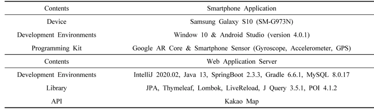
1. 스마트폰 애플리케이션 및 웹 애플리케이션 서버 개발 흉고직경 및 수고 등 다양한 임목 정보들을 한 번에 취득하 고 효과적으로 관리하기 위해 스마트폰 애플리케이션 및 웹 애플리케이션 서버(Web Application Server, WAS)를 개 발하였으며, 개발환경과 라이브러리 등은 Table 1과 같다. 개발 프로세스는 크게 두 가지로 구분되며, 먼저 스마트 폰 애플리케이션은 Google AR Core에서 제공하는 증강현 실(Augmented Reality, AR) API(Application Programming Interface)와 스마트폰(SM-G973N, Samsung, Suwon)에 내 장되어있는 동작센서(자이로스코프, 가속도계, GPS)를 이 용해 임목의 흉고직경, 거리, 수고, 방위, 고도, 위치 좌표 를 측정하여 WAS로 전송한다. 데이터 수신이 고르지 않 을 경우, 스마트폰 내부 저장소에 측정값을 리스트 형태로 저장한 후, 온라인 환경에 노출되었을 때 WAS로 순차적 인 전송이 되도록 하였다. 또한, WAS는 스마트폰 애플리 케이션이 측정한 데이터를 수신받아 웹상에서 데이터를 관리하고 조회, 출력할 수 있게 IntelliJ 2020.02, Java 13, Spring Boot 2.3.3, Gradle 6.6.1, MySQL 8.0.17 개발환경 과 카카오 맵 API를 이용하여 개발하였다(Figure 1).Contents Smartphone Application
Device Samsung Galaxy S10 (SM-G973N)
Development Environments Window 10 & Android Studio (version 4.0.1)
Programming Kit Google AR Core & Smartphone Sensor (Gyroscope, Accelerometer, GPS)
Contents Web Application Server
Development Environments IntelliJ 2020.02, Java 13, SpringBoot 2.3.3, Gradle 6.6.1, MySQL 8.0.17
Library JPA, Thymeleaf, Lombok, LiveReload, J Query 3.5.1, POI 4.1.2
API Kakao Map
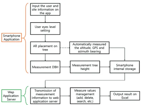
Figure 1. Workflow of the tree measurement using smartphone application and web application server (WAS).
2. 현장적용 시험
개발된 스마트폰 애플리케이션의 정확성을 평가하기 위해 인공 침엽수림에서 잣나무 90본과 천연 혼효림에서 무작위로 90본씩 총 180본을 선정하여 스마트폰 애플리 케이션, 버텍스(Vertex laser geo, Haglöf, Sweden) 및 윤척 (Haglöf Mantax Blue Caliper, Haglöf, Sweden)으로 조사 하였다. 조사된 데이터는 IBM SPSS Statistic 25으로 회귀 분석을 이용하여 비교ㆍ분석하였으며, 식 1을 이용하여 평균 제곱근 오차(Root Mean Square Error, RMSE)를 산 출하였다.
(1)• : tree height and DBH determined with smartphone app
• : tree height and DBH determined with vertex and caliper
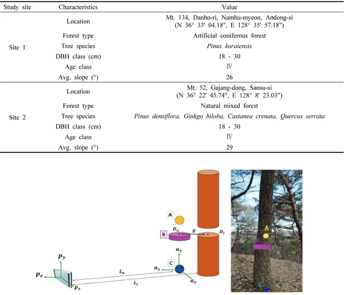
• : number of measurements 연구대상지는 임상 및 임종에 따른 스마트폰 애플리케 이션의 정확성 검증을 위해 영급, 경급, 경사도가 일치하 는 곳을 선정하였다(Table 2). 인공 침엽수림은 안동시 남 후면 단호리 산 134에 위치한 잣나무 조림지로 하층식생 이 많이 자라지 않은 상태였으며, 천연 혼효림은 상주시 가장동 산 52에 위치한 혼효림으로 하층식생이 많고 수형 이 곧지 않은 임목들이 다수 분포하였다.
결과 및 고찰
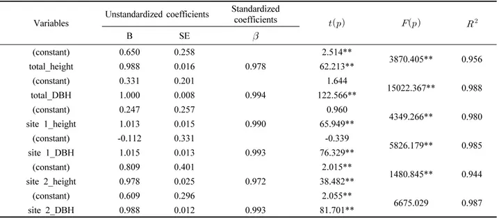
1. 스마트폰 애플리케이션 및 웹 애플리케이션 서버 개발 AR과 동작센서를 활용하여 임목의 흉고직경, 거리, 수 고, 방위, 고도, 위치 좌표를 측정할 수 있는 스마트폰 애플 리케이션 개발 및 구성 화면, 그리고 측정된 값들을 조회 하고 관리할 수 있는 WAS 개발 내용은 다음과 같다. 1) 증강현실(Augmented Reality) AR은 가상현실(Virtual Reality, VR)의 한 분야로써 현실 세계에 배치되는 AR 객체는 실제 사물과 유사한 크기를 표현할 수 있으며, 3개의 좌표축(, , )에 대한 방향성 을 가진다. 이러한 특징을 이용해 AR 객체가 임목의 흉고 직경과 거리를 측정할 수 있도록 구현하였다(Figure 2). 사 용자가 임목 앞에 AR 객체를 배치하며, 배치된 AR 객체는 Figure 2의 A, B, C와 같다. A는 사용자 눈높이를 나타내며, 경사 측정에 사용된다. 이때의 눈높이는 사용자가 직접 설 정할 수 있도록 하였다. B는 지상으로부터 1.2 m 높이에 배치되며, 윤척과 동일한 방식으로 좌우 길이를 조절하면 서 흉고직경을 측정하며, C는 A, B를 이동 및 고정하는Site 1
Location
(N 36° 33' 04.18", E 128° 35' 57.18")
Forest type Artificial coniferous forest
Tree species Pinus koraiensis
DBH class (cm) 18 - 30
Age class Ⅳ
Avg. slope (°) 26
Site 2
Location Mt. 52, Gajang-dong, Sansu-si
(N 36° 22' 45.74", E 128° 8' 23.03")
Forest type Natural mixed forest
Tree species Pinus densiflora, Ginkgo biloba, Castanea crenata, Quercus serrata
DBH class (cm) 18 - 30
Age class Ⅳ
Avg. slope (°) 29
Figure 2. AR objects placed in the real world. A represents the user eyes height, B represents the measurement DBH, C allows A, B to move and fixed in real world and calculate the distance using the
, , coordinates of the AR object and the , , coordinates of the smartphone, and
develop a method to minimize the error in measuring the due to the difference in distance between the AR object and the tree().
역할을 한다. AR 객체는 현실 세계에 배치되는 순간부터 , , 값을 부여받으며, 스마트폰 또한 , , 값을 가진다. 이를 식 2에 적용하여 사용자와 AR간의 거리()를 구하 였다.
(2)• : Distance between AR and smartphone (coordinate )
• : coordinates of AR object • : coordinates of smartphone • : Distance between user and AR object (m) B는 임목의 앞에 배치되므로 흉고 부분에 밀착되지 않
고 일정 거리()가 떨어지게 된다. 이로 인해 실제 임목의
흉고직경()과 B를 이용해 측정되는 흉고직경()간에
원근법으로 인한 오차가 발생하게 된다. 이를 보정하기 위
()에 보정값 2 cm를 더해 추정하였으며, 에 를 더 함으로써 사용자와 임목 간의 거리()를 구하였다. 이때, 보정값은 오차율이 가장 적게 나타나는 값을 경험적으로 선택하였다. 이후 는 식 3과 같이 비례식을 이용하여 계산하였다. × (3)
• : Distance between trees and B (cm) • : B object DBH (cm)
• : Tree DBH (cm)
• : Distance between user and AR objects (m) • : Distance between user and tree (m)
임목의 흉고 부분이 휘어있는 경우를 대비하여 B가 회 전할 수 있도록 사원수(Quaternion)를 이용하였다. 사원수 는 , , 의 회전축()에 대해 회전하고자 하는 각도() 를 식 4를 이용해 산출하였다. 사원수는 오일러 수를 사용 하였을 때 발생되는 짐벌락(Gimbal lock) 현상을 피할 수 있어 회전 기능 구현에 사용하였다(Figure 3). cos (4)
• : Quaternion rotation angle(°) • : Rotation angle(°)
• : Rotate axis of AR object
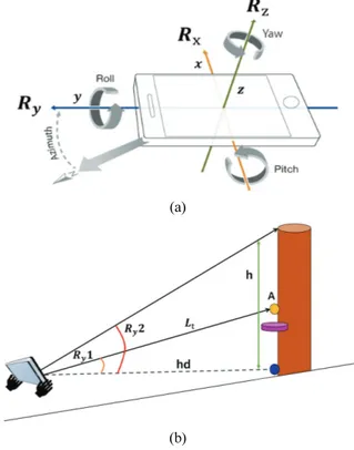
Figure 3. Rotation and rotation angle adjustment function of AR object with quaternion applied to measuring the curved breast height area. is axis of the rotate. is rotate angle. , , is coordinate the AR object. 2) 동작센서 안드로이드 기반 스마트폰은 기기의 3차원적인 동작을 감지하는 가속도계와 자이로스코프 센서가 있다[Figure 4(a)]. 이를 활용해 수고, 경사, 방위, 수평거리를 측정하였 으며, 고도 및 위치 좌표는 기압센서와 GPS 센서를 이용 하였다. 먼저 가속도계는 세 개의 좌표축에 대한 가속력 데이터를 반환하고 자이로스코프는 세 개의 좌표축에 대 한 회전 속도 데이터를 다차원적 배열로 반환하는데, 각 축을 중심으로 스마트폰을 만큼 회전시킬 때 반환되는 회전 행렬은 식 5와 같다. 본 연구에서는 를 이용하여 경사와 수고를 측정하였으며, 를 이용해 8 방위각을 산 출하였다. 축을 회전하여 얻는 를 사용해 수고를 측정 할 수 있으나, 스마트폰을 세로로 사용하는 것보다 가로로 사용하는 것이 안정성이 있으므로, 본 연구에서는 축을 회전하여 얻는 를 삼각함수에 적용하여 경사와 수고를 측정하였다. 사용자가 A를 향해 첫 번째 를 얻으면 식 6을 이용하여 경사(°)를 측정한 후, 스마트폰을 초두부에 (a) (b)
Figure 4. Smartphone sensor system and measurement of tree height using motion sensor.
(a) Smartphone rotation about , , axis. Pitch is rotation about axis () and roll is rotation about axis (). Yaw is rotation about axis (). (b) The sensor built into the smartphone can acquire the , and estimate the tree height and azimuth by applying trigonometry using the value. The azimuth bearing was calculated using
cos sin sin cos (5)
cos sin sin cos
cos sin sin cos • : Smartphone axis rotation matrix × (6)
cos ×
tan ×
(7)
• : The y-axis rotation angle of the smartphone as it faces Figure 3b
• : The y-axis rotation angle of the smartphone as it faces tree top
• : Horizontal Distance(m)
• : Distance between user and AR objects(m) • : Tree height(m) 적인 정보를 입력하는 화면과[Figure 5(a)] 사용자가 AR 객체를 현실세계에 배치하고, 배치되는 동시에 고도, 방 위, 사용자 간의 거리가 계산되며, 흉고직경 측정 장치를 통해 흉고직경을 측정할 수 있는 화면[Figure 5(b)], 동작 센서를 활용하여 수고, 경사를 측정하고 측정된 모든 정보 를 WAS로 전송할 수 있는 화면으로 구성된다[Figure 5(c)].
(4) 웹 애플리케이션 서버(Web Application Server)
WAS는 SpringBoot 2.3.3을 백엔드로 스마트폰을 통해 측정된 정보들을 모두 관리하고 Intelli J 2020.02 및 Java 13을 프론트엔드로 사용하여 사용자에게 정보를 조회, 출 력할 수 있게 구성하였다(Figure 6). 정보 조회는 위치기 반, 날짜 기반, 표준지 번호에 따라 측정정보를 조회 및 출력할 수도 있고, MySQL 8.0.17을 이용하여 정보 저장 및 스프레드 시트 파일로 다운로드할 수 있게 구현하였다 [Figure 6(b)]. 또한, 카카오 맵 API에 임목의 위치가 표시 되며 아이콘에 마우스를 올려놓으면 해당 임목에 대한 정 보가 표시되도록 하였다. 2. 현장적용 시험 개발된 스마트폰 애플리케이션의 정확성을 평가하기 위 해 인공 침엽수림에서 잣나무 90본과 천연 혼효림에서 무 작위로 90본씩 총 180본을 선정하여 스마트폰 애플리케이 션, 버텍스, 윤척으로 조사하고 비교⋅분석한 결과, 임상 (a) (b) (c)
Figure 5. Configuring of smartphone and web application.
(a) (b)
Figure 6. Web application server that stores and manages data measured by the smartphone application. (a) On the web server, user can search for the location of the tree, the height of the DBH, and the number of the tree,
and user can add and modify it. (b) WAS can be output as spread sheet file.
Variables
Unstandardized coefficients Standardized
coefficients B SE
(constant) 0.650 0.258 2.514** 3870.405** 0.956 total_height 0.988 0.016 0.978 62.213** (constant) 0.331 0.201 1.644 15022.367** 0.988 total_DBH 1.000 0.008 0.994 122.566** (constant) 0.247 0.257 0.960 4349.266** 0.980 site 1_height 1.013 0.015 0.990 65.949** (constant) -0.112 0.331 -0.339 5826.179** 0.985 site 1_DBH 1.015 0.013 0.993 76.329** (constant) 0.809 0.401 2.015** 1480.845** 0.944 site 2_height 0.978 0.025 0.972 38.482** (constant) 0.609 0.296 2.055** 6675.029 0.987 site 2_DBH 0.988 0.012 0.993 81.701** **: α<.05Table 3. Results of regression analysis on tree heights and DBH acquired from the both study sties.
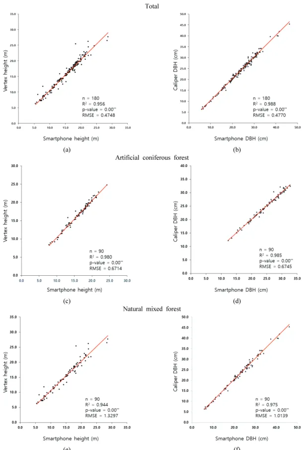
에 상관없이 수고와 흉고직경 모두 값이 3870.405( <0.05)와 15022.367(<0.05) 이므로 본 회귀모형이 적합하 였으며, 특히 흉고직경이 수고보다 더 적합한 것으로 분석 되었다. R2는 평균 0.972로 높은 설명력을 가지며, 비표준화 계수 B값이 모두 0.5 수준보다 높으므로 스마트폰으로 취 득한 수고와 흉고직경 값이 버텍스와 윤척으로 취득한 값 과 정적인 관계를 나타내는 것으로 분석되었다(Table 3). 인공 침엽수림에서의 버텍스와 스마트폰의 수고 비교 결과, RMSE가 0.6714 m의 차이를 나타내었으며 R2또한 0.980으로 매우 높은 상관관계를 가지는 것으로 분석되었 다. 흉고직경은 RMSE가 0.6745 cm의 차이를 나타냈으며, R2가 0.985의 높은 상관관계를 보였다. 이러한 수고와 흉 고직경 분석결과는 모두 선행연구(Fan et al., 2020)보다 높은 정확도를 나타내었다. 천연 혼효림에서의 수고는 RMSE가 1.3297 m이며, R2는 0.944로 인공 침엽수림에 비 해 낮은 상관관계를 가지는 것으로 분석되었다. 흉고직경 은 RMSE가 1.0139 cm의 차이와 R2가 0.975로 흉고직경은 아주 근소한 차이를 나타내었다(Figure 7). 이는 천연 혼효림 에서의 초두부 확인이 인공 침엽수림에 비해 어려워 이러한 결과가 나타난 것으로 판단된다.
(a) (b) Artificial coniferous forest
(c) (d)
Natural mixed forest
(e) (f)
Figure 7. Simple regression analysis of DBH and tree height measurements on stand data acquired from the both study sties. (a) Results of total tree height. (b) Results of total DBH. (c) Results of tree height in site 1. (d) Results of DBH in site 1. (e) Results of tree height in site 2. (f) Results of DBH in site 2.
이처럼 본 연구는 이론적으로 정확한 기하학적 높이, 크 기를 설명할 수 있었으나, 스마트폰 기기에 따라 센서 감 도가 상이하여, 측정오차 또한 달라질 수 있다(Molinier et al., 2016). 특히 임목 위치 파악을 위해 사용된 스마트폰 GNSS(Global Navigation Satellite System) 기능은 임분밀 도에 크게 영향을 받아 정확성이 낮거나 측정할 수 없는 경우가 발생할 수 있다(Korpilo et al., 2017). 또한, 흉고직경 측정을 위해 응용한 AR 기술은 스마트 폰 배터리 소모를 가속시키며, 천연 혼효림과 같이 지형이 고르지 못하거나 관목이 많을 경우, 산림 내에 AR 객체를 배치시키기 어려워 작업 시간이 증가 되는 단점이 발생하 였다. 본 연구에서 개발한 스마트폰 애플리케이션은 인공 침엽수림, 천연 혼효림에서 모두 조사는 가능하였으나, 위 와 같은 스마트폰의 기술적 한계로 인해 천연 혼효림에서 의 활용은 인공 침엽수림에 비해 다소 부정확한 것으로 사료되며, 타 스마트폰에 적용할 경우 측정 오차가 달라질 수 있을 것으로 판단된다. 그러나 스마트폰은 기존 산림조사 장비에 비해 휴대성 이 우수하고 비용 효율적이며, 타 장비와의 높은 호환성 등 기능적 활용성이 높아 LiDAR(Light Detection and Ranging), 무인 항공기, SLAM(Simulataneous Localization and Mapping) 기술과의 융합이 가능하다. 이에 따라 다양 한 스마트폰을 활용한 산림 분야 적용 연구 및 표준지 매 목조사를 통한 현장적용 시험 연구 등이 지속적으로 수행 될 필요가 있는 것으로 판단된다.
결 론
본 연구는 스마트폰을 산림조사에 활용하고자 스마트폰 애플리케이션 및 WAS를 개발하였다. 개발된 스마트폰 애 플리케이션은 AR을 이용하여 흉고직경 및 거리를 산출하 고 사원수 함수를 이용해 흉고 부위가 휘어져 있어도 측정 할 수 있도록 하였다. 또한, 동작센서인 자이로스코프와 가 속도계를 이용해 스마트폰의 , , 축의 움직임을 모니터 링하여 기울어진 각도를 취득하고 이를 삼각법에 적용함으 로써 임목의 수고와 수평거리, 방위를 산출하였으며, 그 밖 의 기압센서, GPS 등을 이용해 고도, 위치 좌표를 측정할 수 있도록 개발하였다. WAS는 스마트폰이 측정한 모든 정 보를 저장하고 조회 및 처리할 수 있도록 SpringBoot 2.3.3 을 벡엔드로 구현하였으며, 사용자가 정보를 관리하고 수 정할 수 있게 IntelliJ 2020.02와 Java 13을 이용해 프론트 엔드를 구성하였다. 또한, MySQL 8.0.17로 측정된 정보를 스프레드 시트 형태로 출력할 수 있게 최종 개발하였다. 개발된 스마트폰 애플리케이션의 정확성 검증을 위해 인 공 침엽수림과 천연 혼효림에서 각 90본씩 총 180본을 대 상으로 기존 산림조사 장비인 버텍스 및 윤척과 비교⋅분 석한 결과, 평균 R2가 0.972로 매우 높은 상관관계를 보였 다. 흉고직경의 경우 인공 침엽수림에서 평균 제곱근 오차 가 0.6745 cm, 천연 혼효림에서는 1.0139 cm를 보였다. 수고의 경우 인공 침엽수림에서는 평균 제곱근 오차가 0.6714 m, 천연 혼효림에서는 1.3297 m로 분석되어 기존 산림조사 장비와 큰 차이가 없는 정확도를 보여주었다. 그 러나 지형이 고르지 않을 시 AR 객체의 배치가 어려운 문제가 발생하였으며, 임목의 위치를 WAS에 전송하기 위 해 위치 좌표점을 수신해야 하나 산림 내 수관이 밀하거나 데이터가 수신되지 않는 지역에 다다르면 GPS 수신이 제 대로 되지 않는 문제가 발생했다. 그러나 스마트폰은 기존 산림조사 장비에 비해 휴대성이 우수하고 비용 효율적이 며, 타 장비와의 높은 호환성 등 기능적 활용성이 높다. 또한, 스마트폰은 보급률이 상당히 우수하므로 스마트폰 을 임업 분야에 활용하고자 하는 본 연구가 의미 있다고 사료되며, 스마트폰의 한계점을 타개할 방법론적인 연구 가 다양하게 시도되어야 할 필요가 있다고 판단된다.감사의 글
본 연구는 산림청(한국임업진흥원) 산림과학기술 연구 개발사업(2020246A00-2021-0001) 지원에 의하여 이루어 진 것입니다.References
Bijak, S. and Sarzyński, J. 2015. Accuracy of smartphone applications in the field measurements of tree height. Journal of Folia Forestalia Polonica, Series A. 57(4): 240-244.
Fan, G., Chen, F., Li, Y., Liu, B. and Fan, X. 2019. Develop-ment and testing of a new ground measureDevelop-ment tool to assist in forest GIS surveys. Journal of Forests 10(8): 643. Fan, G., Dong, Y., Chen, D. and Chen, F. 2020. New method
for forest resource data collection based on smartphone fusion with multiple sensor. Journal of Mobile Information Systems. 2020. Article ID 5736978. pp. 11. http://doi.org/1 0.1155/2020/5736978.
Fan, Y., Feng, Z., Shen, C., Khan, T.U., Mannan, A., Gao, X., Chen, P. and Saeed, S. 2020. A Trunk-Based SLAM Backend for Smartphones with Online SLAM in Large Scale Forest Inventories. Journal of Photogrammetry and Remote Sensing 162(4): 41-49.
Fauzi, M.F., Idris, N.H., Din, A.H.M., Osman, M.J., Idris, N.H. and Ishak, M.H.I. 2016. Indigenous community tree
Han, D. and Dong, C. 2011. Tree height measurement based on image processing with 3-points correction. Proceedings of the 2011 International Conference on Computer Science and Network Technology. pp. 2281-2284. Harbin, China, December 2011.
Han, S., Seale, R.D. and Shmulsky, R. 2018. An exploratory study of smartphone and smartphone application use in the U.S. Forest Products Industry.
Itoh, T., Eizawa, J., Yano, N., Matsue, K. and Naito, K. 2010. Development of software to measure tree heights on the smartphone. Journal of the Japanese Forest Society 92(4): 221-225.
Jung, S.H. and Sim, C.B. 2012. A study on ubiquitous tree management system based on GIS and smart-phone for efficiency of arboreal growth management. Journal of the Korea Society of Computer and Information 17(6): 119-130.
Kim, C.Y., Shim, Y.K. and Kim, K.W. 2010. Development of ecological trail informations using two dimensional barcode. Proceedings of the 2010 Conference on Korean Institute of Forest Recreation and Welfare. pp. 64-67. Kitahara, F., Mizoue, N. and Yoshida, S. 2010. Effects of
Training for Inexperienced Surveyors on Data Quality of Tree Diameter and Height Measurements. Journal of Silva Fennica. 44(4): 657-667.
Korpilo, S., Virtanen, T. and Lehvävirta, S. 2017. Smartphone GPS tracking-inexpensive and efficient data collection on recreational movement. Journal of Landscape and Urban Planning 157(1): 607-617.
of Remote Sensing 8(10): 869.
Qu, Y., Wang, J., Song, J. and Wang, J. 2017. Potential and limits of retrieving conifer leaf area index using smartphone-based method. Journal of Forests 8(6): 217. Täll, K. 2020. Accuracy of mobile forest inventory application
KatamTMForest: Evaluation of accuracy in different forest types and comparison to conventional inventory methods. Second Cycle, A2E. Alnarp: SLU, Southern Swedish Forest Research Centre.
Vastaranta, M., Latoree, E.G., Luoma, V., Saarinen, N., Holopainen, M. and Hyyppä, J. 2015. Evaluation of a smartphone app for forest sample plot measurements. Journal of Forests 6(4): 1179-1194.
Villasante, A. and Fernandez, C. 2014. Measurement errors in the use of smartphones as low-cost forestry hypsometers. Journal of Silva Fennica 48(5), article id 1114.
Wu, X., Zhou, S., Xu, A. and Chen, B. 2019. Passive measure-ment method of tree diameter at breast height using a smartphone. Journal of Computers and Electronics in Agriculture 163(8): 104875.
Wu, X., Xu, A. and Yang, T.T. 2020. Passive Measurement Method of Tree Height and Crown Diameter Using a Smartphone. Journal of Institute of Electrical and Electronics Engineers. 8(2020): 11669-11678.
Manuscript Received : January 28, 2021 First Revision : March 8, 2021 Accepted : March 9, 2021